
Six Reasons to USe the FAA - VFR - Raster Charts Link when selling Aviation Real Estate: Download Page
- Erik McCormick
- Jan 24, 2025
- 2 min read

Updated: Feb 7, 2025
Not for navigation purposes


FAA VFR Raster Charts: Essential Tools for Aviation Real Estate Professionals
At AviationRealEstate.com, we're committed to providing innovative solutions for aviation real estate agents. Our latest resource offers easy access to FAA VFR Raster Charts, empowering you to elevate your marketing strategies and enhance client understanding of airspace and distances.
Understanding VFR Raster Charts
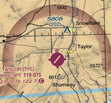
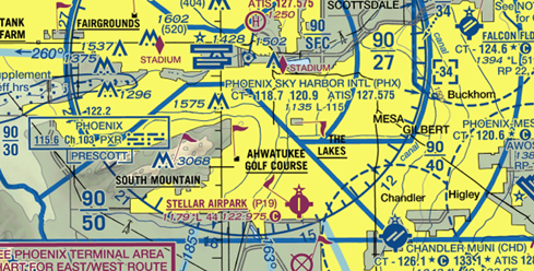
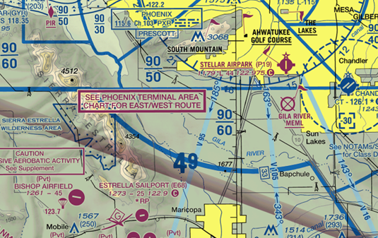
VFR Raster Charts are digital representations of FAA Visual Flight Rules (VFR) charts, including:
Sectional Aeronautical Charts
Terminal Area Charts (TAC)
Helicopter Route Charts
Advantages for Aviation Real Estate Agents
Property Visualization: Showcase airparks, hangar homes, and private ranches with runways in relation to airports and airspace.
Distance Analysis: Illustrate flight times and distances between aviation properties and key locations.
Airspace Education: Explain airspace classifications and their impact on aircraft hangar sales and airpark developments.
Enhanced Marketing: Create compelling visual aids for runway home listings and presentations.
Client Comprehension: Improve clients' understanding of aviation-specific factors in real estate decisions.
No Cost - Use Appropriately
Accessing and Utilizing VFR Raster Charts
Download: Obtain charts directly from AviationRealEstate.com's resource page.
GIS Integration: Overlay additional data on charts using Geographic Information System software.
Regular Updates: Stay current with charts updated every 56 days.
Available Chart Types
Sectional Aeronautical Charts: Perfect for visualizing large areas and regional context of airparks and private airstrips.
Terminal Area Charts: Detailed information for properties near major airports, ideal for commercial aircraft hangar leases.
Helicopter Route Charts: Useful for properties in areas with significant rotorcraft activity.
Maximizing Chart Effectiveness
Study the FAA's Aeronautical Chart User's Guide to understand symbols and notations.
Combine chart data with property boundaries and local zoning information for comprehensive presentations.
Highlight unique selling points of aviation properties, such as proximity to uncontrolled airspace or private runways.
Properly adding content to VFR charts is crucial for several reasons:
Safety: Accurate and unobstructed chart information is vital for pilot navigation and decision-making.
Legal Compliance: Adhering to FAA standards helps avoid potential regulatory issues.
Clarity: Well-integrated custom content enhances the chart's usefulness without compromising its primary function.
Professionalism: Correctly modified charts reflect positively on your aviation real estate business, demonstrating expertise and attention to detail.
By choosing Aviation Real Estate's VFR Chart package, you ensure that all these important aspects are addressed, providing you with a reliable and compliant solution for your aviation real estate needs.
AviationRealEstate.com's VFR Raster Chart resource empowers aviation real estate professionals to provide superior service and stand out in this specialized market. By leveraging these authoritative FAA charts, you can convey complex aviation-related information in a visually appealing and easily understandable format, enhancing your marketing efforts for aircraft hangar sales, airpark runway homes, and private ranches with runways.
FAA VFR Raster Charts are updated every 56 days
to provide the most current airspace, airport, and navigational information. To ensure accuracy, users should check back regularly for updates and download the latest charts before each new cycle. Staying updated helps enhance safety, compliance, and reduces reliance on NOTAMs. Make it a habit to verify chart updates to always have the most reliable flight information.

